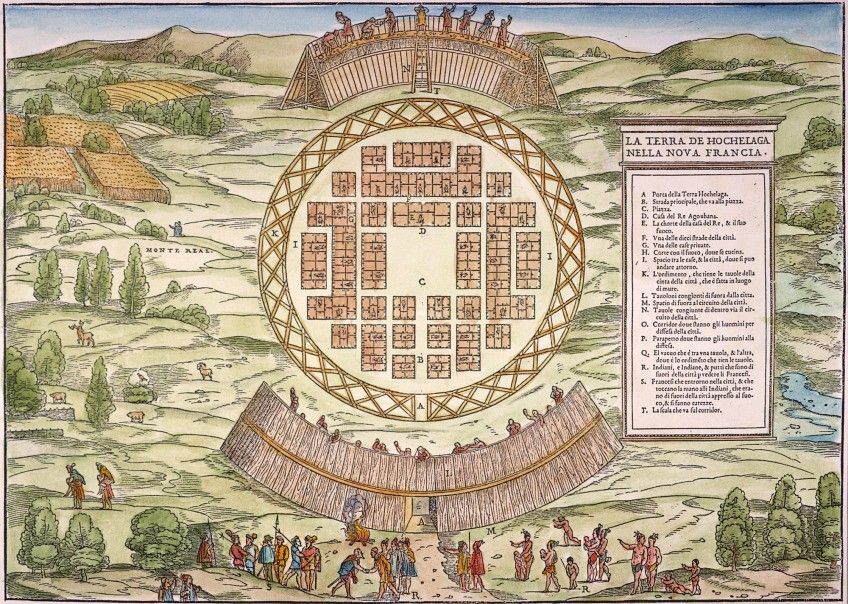
This is a colorful, antique-style map or illustration depicting a planned city called “Hohelaga” in “New France.” The city is laid out in a circular pattern, with a network of streets forming a grid within the circle. **City Layout:** The city is surrounded by a large, wooden palisade wall with a gate visible at the bottom. Inside the wall, the streets intersect at right angles, creating rectangular blocks. Within these blocks are numerous small, rectangular buildings, presumably houses or shops. A central circular area is visible, possibly a plaza or market. A raised circular structure with people on top is visible around the city, possibly a viewing platform or defensive structure. **Landscape:** The city is situated in a lush, green landscape. A river flows through the landscape, and there are trees scattered throughout. Mountains are visible in the background. **People:** Small figures of people are depicted throughout the illustration, engaged in various activities. Some are walking along the streets, while others are gathered in the central plaza. There are also figures on the raised circular structure. **Text:** The right side of the illustration contains a column of text in an old-style font, likely labeling different parts of the city or providing additional information. The top right corner has a title in a similar font. The overall style of the illustration is reminiscent of early maps and city plans, with a focus on detail and a somewhat stylized representation of the landscape and buildings. The colors are vibrant, but have a slightly faded appearance, consistent with the age of the illustration.