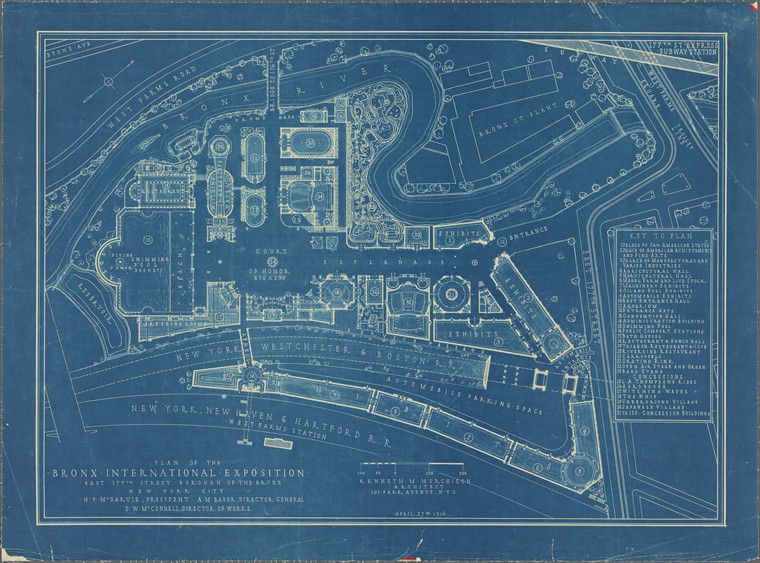
This is a detailed blueprint-style map of the Bronx International Exposition. It's rendered in a monochromatic blue, giving it a vintage, technical drawing aesthetic. The map depicts a complex layout of buildings, roads, and pathways, all arranged within a large, irregularly shaped area. The buildings are represented as rectangular and square shapes, with some having more intricate details suggesting larger or more complex structures. Roads and pathways are depicted as lines, creating a network throughout the exposition grounds. At the bottom of the map, there's a clear indication of transportation access with labels like 'New York, New Haven & Hartford Station.' A 'Key to Plan' is located on the right side, listing and numbering various buildings and areas within the exposition, such as 'Main Building,' 'Agricultural Building,' 'Woman's Building,' and 'Electrical Building.' Text at the bottom identifies the map as 'Plan of the Bronx International Exposition' and includes names like 'H.M. McGrath, Chairman of the Board,' 'J.A.W. Tain, President,' and 'B.W. McConnell, Director of Works,' along with the date 'April 27th 1914.' The overall impression is of a meticulously planned and documented event, captured in a classic blueprint format. The map is dense with information, providing a comprehensive overview of the exposition's layout and features.