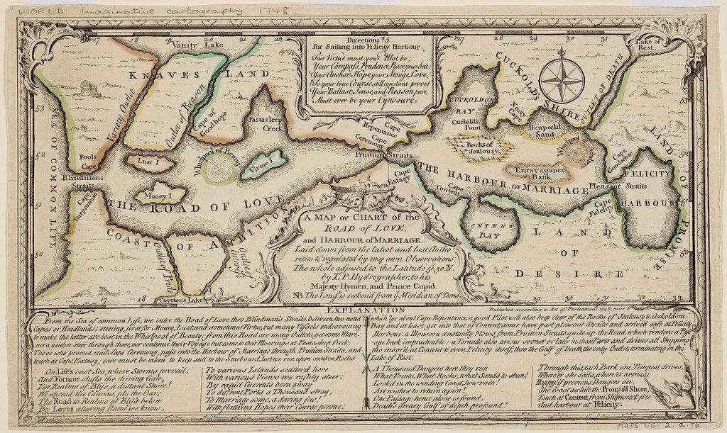
This is an antique map titled "A Map or Chart of the Road of Love and Harbour of Marriage". It's a whimsical, allegorical map depicting a coastline and islands with names representing stages and emotions in love and marriage. The map is rendered in a faded, aged color palette of greens, browns, and creams. The coastline is irregular and detailed, with various bays, inlets, and islands. The map is oriented with North towards the top. Key features and locations on the map include: * **Knaves Land:** A large landmass on the left side. * **Vanity Lake:** Located within Knaves Land. * **The Road of Love:** A winding path along the coastline. * **Coast of Indiscretion:** The coastline bordering the Road of Love. * **Money Island:** An island along the Road of Love. * **The Harbour of Marriage:** A central bay with islands within it. * **Content Bay:** A smaller bay within the Harbour of Marriage. * **Land of Desire:** A landmass to the right of the Harbour of Marriage. * **Lake of Rest:** Located near the Land of Desire. * **Cuckold's Bay:** A bay on the right side. * **Rocks of Jealousy:** Rocks near Cuckold's Bay. A compass rose is prominently displayed near the center-right of the map. Below the map is a detailed "Explanation" in multiple lines of text, describing the allegorical meaning of the various locations and features. The map is framed by an ornate border. The overall style is reminiscent of 18th-century cartography, with a focus on detailed illustration and allegorical representation.