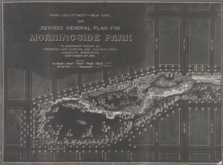
This is a vintage map of Morningside Park in New York City, dated September 26, 1887. The map is rendered in a monochromatic palette, primarily shades of brown and beige, giving it an aged appearance. The park itself is the central focus, depicted with intricate details of its landscape. There are numerous trees, represented by small, dense clusters, suggesting a heavily wooded area. Paths and walkways meander throughout the park, creating a network of routes. The terrain is indicated by contour lines, showing the undulating hills and valleys within the park boundaries. Surrounding the park are city streets, forming a grid pattern. The streets are labeled with their names, such as 110th Street, 116th Street, and Morningside Avenue. Buildings are represented by small, rectangular blocks along the streets, indicating the urban development surrounding the park. At the top of the map, there is a title block that reads "Park Department - New York, 1887, Revised General Plan for Morningside Park." Below the title, it states that the plan was prepared by Frederick Law Olmsted and Calvert Vaux, landscape architects. A scale is also included, showing measurements in feet and meters. The overall impression is that of a meticulously crafted plan, showcasing the design and layout of Morningside Park in the late 19th century. The map provides a detailed view of the park's landscape, its relationship to the surrounding urban environment, and the vision of its creators.