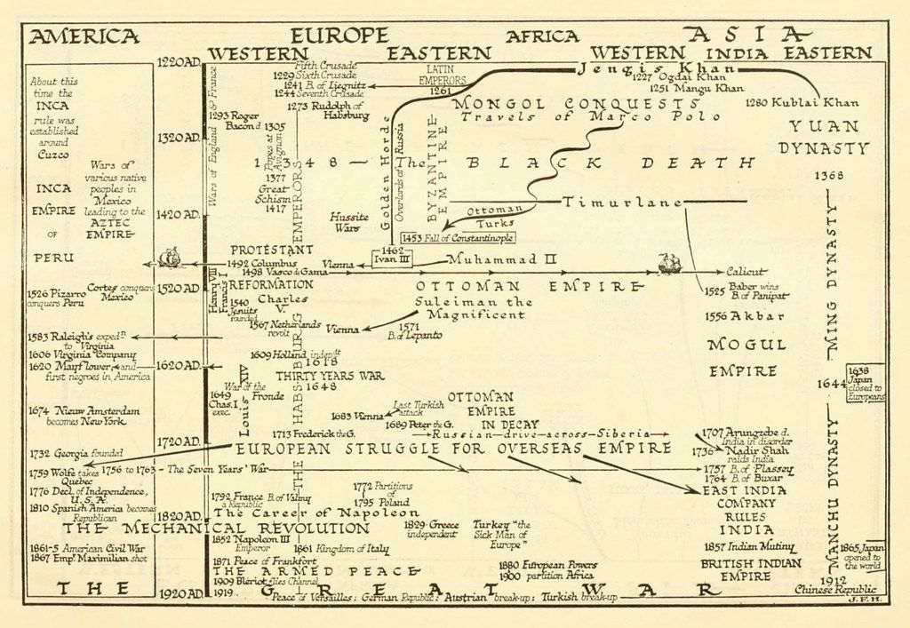
The image is a historical timeline map of the world, spanning from approximately 1200 AD to 1700 AD. It's divided into four main sections: America, Europe, Africa, and Asia, each with its own timeline running vertically. The timelines are filled with significant historical events, battles, and the rise and fall of empires. **Key Features:** * **Color Scheme:** The map uses a muted, vintage color palette, primarily shades of beige, brown, and green, giving it an aged appearance. * **Timeline Structure:** Each region's timeline is represented by a vertical line with dates marked along it. Events are indicated by text labels and small illustrations. * **Regional Focus:** * **America:** Shows the Inca Empire, Aztec Empire, and the arrival of Europeans like Pizarro and Raleigh. * **Europe:** Highlights events like the Crusades, the Reformation, the Thirty Years' War, and the rise of various European powers. * **Africa:** Focuses on the Ottoman Empire's expansion into North Africa and the slave trade. * **Asia:** Details the Mongol conquests, the rise of the Yuan and Ming dynasties, and the Mughal Empire. * **Illustrations:** Small drawings depict key figures, battles, and cultural elements, such as ships, castles, and portraits. * **Text:** The map is densely packed with text labels, dates, and descriptions of historical events. * **Overall Style:** The map has a hand-drawn, illustrative style, reminiscent of historical maps and charts. It's designed to provide a comprehensive overview of world history during the specified period. **Notable Events and Empires:** * Mongol Conquests * Black Death * Ottoman Empire * Inca Empire * Aztec Empire * Reformation * Thirty Years' War * Yuan Dynasty * Ming Dynasty * Mughal Empire * European Exploration and Colonization **Overall Impression:** The image is a detailed and informative historical map that provides a visual representation of world history between 1200 and 1700 AD. It's a valuable resource for students and anyone interested in learning about this period.